


GMX200 多功能显示器(标准版)
当前位置:首页 > 湖南天翼航空设备有限公司 >> 航空电子产品 >> 其它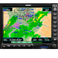
GMX200 多功能显示器(标准版)
详细介绍
GMX 200 Getting the big picture Big-Picture Display | |||||||||||||||||
| Big-Time Features Similar to its predecessor, the MX20? the GMX 200 is easy-to-use with multiple functions and useful features that make navigation simple and provide an extra margin of safety:
| |||||||||||||||||
Detailed Data
The GMX 200 includes high resolution terrain and hydrography data for the entire world which is preloaded for an unmatched presentation even at the lower zoom scales. The Garmin Base Map with cities, roads, rivers, and lakes has been added to further improve situational awareness. An aviation database featuring Jeppesen?NavData?is used to draw airports, airways, navaids, airspace, and more. Map scales range from one-fourth of a mile to a whopping 2500 miles. A unique split screen function allows you to simultaneously view two charting options along with the vertical profile for the elevation of the terrain along the route of flight. | |||||||||||||||||
|
|
| |||||||||||||||
| Seamless Integration With the addition of the GDL 69, you can add XM WX Satellite Weather information to the GMX 200. Graphical weather depictions including NEXRAD, METARs, TAFs, TFRs, winds aloft, echo tops, precipitation type at the surface, lightning strikes, storm-cell data, AIRMETs, and SIGMETs can be received and displayed regardless of altitude. Combine animated NEXRAD images with the maximum zoom range of 2500nm and a nationwide view of the weather is presented on one screen. The GMX 200 also provides a user interface for the more than 150 channels of XM audio with the GDL 69A. Similar to the MX20, the GMX 200 comes in three versions: Standard, Traffic, and Radar/Traffic. GMX 200 Radar/Traffic ?supports traffic interfaces and can also be interfaced with Garmin抯 GWX 68? a new color digital weather radar with 6.5 KW of transmit power. When connected to the GWX 68? the Radar/Traffic model displays real-time weather ahead of the aircraft supporting both horizontal and vertical perspectives. The GMX 200 may be interfaced with the Garmin 400/500 series, GNS 480? Garmin GDL 69/69A, Garmin GTX 330/33? Garmin GDL 90? Garmin GWX 68, as well as many other manufactures' GPS navigation equipment. | |||||||||||||||||


