


GARMIN综合导航设备(Refurbished)
当前位置:首页 > 湖南天翼航空设备有限公司 >> 航空电子产品 >> 导航系统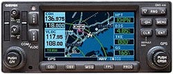
GARMIN综合导航设备(Refurbished)
产品编号:
规格/型号:GNS 430
件号:
产地:美国
制造商:Garmin
价格:点击询价
美金价格: 抱歉!您还没有权限查看!
浏览次数: 908 次
详细介绍
| SPECIFICATIONS | |||
| Coverage: | Americas or International | Airports: | Identifier, city/state, country, facility name, lat/long elevation, fuel service, control, approach information |
| VORs: | Identifier, city/state, country, facility name, lat/long, frequency, co-located DME/TACAN, magnetic variation, weather broadcast | NDBs: | Identifer, city/state, country, facility name, lat/long, frequency, weather broadcast |
| Intersections: | Identifier, country, lat/long, nearest VOR | Frequencies: | Approach, arrival, control area, departure, Class B, Class C, TMA, TRSA-with sector, altitude and text usage info, also, ASOS, ATIS, AWOS, center, clearance delivery, ground, pre-taxi, tower, unicom, localizer and ILS |
| Runways: | Designation, length, width, surface, lighting, pilot-controlled lighting freq. | FSS: | Identifier, reference VOR, freq. usage |
| ARTCC: | Identifier, freq. usage | MSA: | Minimum safe altitude along and in proximity to active flight plan |
| Approaches: | Non-precision and precision approaches throughtout the database coverage | SIDs/STARs: | Contains all pilot-nav SIDs and STARs |
| Waypoints: | 1000 user-defined | Flight Plans: | 20 reversible; up to 31 waypoints each |
| Emergency Search: | 9 nearest airports, VOR's, NDB's, intersections, or user waypoints; 2 nearest FSS with frequncies; 2 nearest ARTCC frequencies | Alarms: | Arrival and CDI, timers, SUAs less than 10 min, 2NM and insude SUA |
| Receiver: | PhaseTrac12, 12 parallel channel receiver, simultaneously tracks and uses up to 12 satellites | Acquisition Time: | 12 seconds (warm), 45 seconds (cold) |
| Update Rate: | 1/second, continuous | Accuracy: | 15 meters (49 feet) RMS, 1.5 meters with differential corrections |
| Nav Features: | Pilot-defined Course Selection and Waypoint Hold, Closest Point of Approach, Departure and Arrival Frequencies, Approach Navigation using published approach procedures stored on NavData card, Terminal Navigation using SIDs/STARs from NavData card | Planning Features: | True Airspeed, Density Altitude, Winds Aloft, RAIM Availability, Sunrise/Sunset Times, Trip and Fuel Planning, Vertical Navigation (VNAV) |
| Interfaces: | ARINC 429, Aviation RS-232, CDI/HSI, RMI (digital: clock/data), Superflag Out, altitude (serial: Icarus, Shadin-Rosetta, encoded Gillham/Greycode), fuel sensor, fuel/air data | Map Datums: | 124 predefined, 1 user defined |
| VOR Freq. Range: | 108.00 MHz to 117.95 MHz | VOR/LOC Composite: | 0.50Vrms/0.35Vrms |
| CDI Output: | +-150mV Full Scale | Centering Accuracy: | +-2.0 deg. |
| Flag Sensitivity: | -103.5 dBm | DME Channeling: | 2x5 available |
| Audio Sensitivity: | -103.5 dBm for 6 dB S/N with 1 kHz 30% mod. | VOR Audio Output: | -103.5 mW minimum into 500 ohm load; external amplifier required |
| GS Freq. Range: | 329.15 MHz to 335.00 MHz | GS CDI Output: | +-150mV Full Scale |
| LOC Freq. Range: | 108.10 MHz to 111.95 MHz | LOC CDI Output: | +-150mV Full Scale |
| LOC Accuracy: | <4.5mV | LOC Flag Sens.: | -103.5 dBm |
| Size: | 6.25"W x 2.65H x 11.0"L | Weight: | 6.6 lbs. |
| Display: | Color LCD | Power: | 14/28 VDC |
| Certification: | GPS: TSO C129a, Class A1 (en route, terminal, and approach) VOR: TSO C40c LOC: TSO C36c GS: TSO C34e VHF COM: TSO C37d, Class 4 and 6 (transmit) and TSO C38d, Class C and E (receiver) | VHF Frequency Range: | 118.000 MHz to 136.976 MHz |
| Comm Transmit Power: | 10 watts min. | Comm Modulation: | 70% |
| Receiver Sensitivity: | 2.0 microvolts for 6dB S/N with 1 kHz 30% mod. | Comm Channels: | 760 (25 Khz spacing); configuration for 2280 channels (8.33 kHz spacing) also provided |
| Frequency Display: | Upper left corner of active matrix LCD, 2-lines with active freq. above standby | Squelch Sensitivity: | 2.0 microvolts typical |
| Audio Output: | 100mW min. into a 500 ohm load; external amp required | Temperature: | -20 to +55C operating |
| Humidity: | 95% non-condensing | Altitude Range: | -1500 ft. to 50000 ft. |
